Drone surveys have become the standard method for quarry mapping, volume estimation, and compliance documentation in Karnataka. Whether you operate a building stone quarry, a granite extraction site, a laterite block quarry, or a sand mining lease, a drone survey gives you measured data that manual methods simply cannot match. This guide explains how drone surveys work for quarries, what you get as deliverables, how the data is used for compliance, and what it costs.
Axesmap has completed quarry drone surveys across more than 20 districts in Karnataka — covering every major quarrying region in the state. This guide is based on our direct experience working with quarry operators, mine owners, and the regulatory requirements they deal with.
Why Quarries Need Drone Surveys
Quarry operators need accurate spatial data for three reasons: operational decision-making, financial reconciliation, and regulatory compliance.
Operational decisions require knowing the exact geometry of the pit — how deep it is, how the bench faces are progressing, where the extractable material is, and how much is left. This data drives blasting plans, equipment deployment, haul road design, and expansion planning. Without accurate terrain data, these decisions are based on visual estimates and experience rather than measured facts.
Financial reconciliation depends on knowing exactly how much material has been extracted, how much is sitting in stockpiles, and how much has been dispatched. The gap between estimated and actual volumes in a typical quarry operation using manual methods is 10–20%. Over a year of operations, this gap translates directly into revenue that is either uncounted or overcounted — a problem for owners, contractors, and buyers alike.
Regulatory compliance — whether reporting to the Karnataka Department of Mines and Geology (DMG), the Indian Bureau of Mines (IBM), or district-level authorities — requires documented, verifiable data on extraction volumes, lease boundary adherence, and environmental setbacks. Drone survey data with its georeferencing, timestamps, and measured accuracy provides a far stronger compliance record than manual estimates.
How a Drone Survey Works for a Quarry
The process is straightforward and minimally disruptive to quarry operations.
Step 1 — Planning
Before arriving at the site, our team reviews the quarry location, lease boundary, area extent, and any specific requirements from the operator. We plan the drone flight path to cover the entire lease area with sufficient image overlap (typically 75% frontal and 75% side overlap) for accurate photogrammetric processing. We also check the DGCA airspace zone classification for the site and obtain any necessary permissions.
Step 2 — Ground control setup
On the day of the survey, we establish ground control points (GCPs) across the quarry site. GCPs are physical markers placed on stable ground and surveyed with RTK GPS to sub-decimetre accuracy. These points anchor the drone data to real-world coordinates, ensuring the resulting terrain model is geometrically accurate. For quarries where we conduct repeat surveys, the GCPs are permanently marked so they can be reused each time — this ensures consistency between surveys.
Step 3 — Drone flight
Our DGCA-certified remote pilots fly the drone over the quarry in the planned grid pattern. The drone carries a 20MP survey-grade camera and an RTK/PPK GPS receiver. The flight covers the entire lease area — active pit faces, benches, stockpiles, haul roads, dump areas, plant infrastructure, and buffer zones. A typical 5–15 acre quarry takes 10- 15 minutes of flying time. The entire field operation is usually completed in a single day.
Quarry operations do not need to stop during the survey. The drone flies at 60–100 metres above ground level, well clear of ground equipment and personnel. We coordinate with the quarry manager on timing to avoid active blasting windows, but normal extraction, loading, and hauling can continue.
Step 4 — Data processing
The captured aerial images are processed using photogrammetric software to generate a dense 3D point cloud — a precise digital replica of every surface in the quarry. From this point cloud, the orthomosaic map, Digital Terrain Model (DTM), Digital Surface Model (DSM), contour maps, and volume calculations are derived. Processing takes 2-5 working days depending on the quarry size and deliverables required.
Step 5 — Delivery
The complete deliverable package is shared via secure download link with all files in the formats specified by the operator and compatible with mine planning and GIS software.
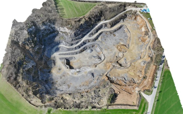
What Gets Surveyed
A comprehensive quarry drone survey covers everything within the lease boundary:
Active pit and bench geometry. The complete 3D shape of the excavation — pit depth, bench heights, bench widths, face angles, ramp gradients, and overall pit progression. This data shows the exact state of the quarry at the time of survey and, when compared against previous surveys, shows exactly how much material has been removed.
Stockpiles. Every stockpile within the lease — crushed material of different grades, raw blocks, overburden dumps, processed aggregates, and reject material. Each stockpile is individually delineated and its volume calculated from the 3D surface model. This replaces manual tape-and-estimate methods with measured data.
Haul roads and ramps. The geometry, gradient, and condition of internal haul roads and access ramps. Useful for planning road maintenance, verifying that gradients are within safe limits for loaded trucks, and calculating material quantities used in road construction or repair.
Overburden and waste dumps. Dump volumes, dump slope angles, and dump progression over time. This data is important for dump stability assessment, waste volume tracking, and environmental compliance.
Lease boundary verification. The high-resolution orthomosaic overlaid with the approved lease boundary coordinates shows clearly whether all mining activity — pit edges, dumps, roads, and infrastructure — is within the approved lease area. This is one of the most critical compliance checks.
Buffer zones and setbacks. Verification that required setback distances from lease boundaries, public roads, habitations, water bodies, and other sensitive features are being maintained as per the licence conditions.
Infrastructure. Crushing plants, weigh bridges, office buildings, worker facilities, and access roads within the lease area — all captured in the orthomosaic for documentation purposes.
Deliverables
Every quarry survey from Axesmap includes:
Orthomosaic map — A high-resolution georeferenced aerial image of the entire quarry at 2.5 cm GSD. Every feature is clearly visible — individual rock faces, bench edges, stockpile shapes, haul road surfaces, plant structures, and boundary markers. Delivered in GeoTIFF format.
Digital Terrain Model (DTM) — A continuous elevation model of the quarry surface. This is the base data for all volume calculations — pit excavation volumes, stockpile volumes, dump volumes, and cut-fill analysis. Delivered in GeoTIFF format.
Digital Surface Model (DSM) — An elevation model showing all surface features including vegetation, structures, and equipment. Delivered in GeoTIFF format.
Contour map — Contour lines at 0.5m or 1m intervals generated from the DTM. Delivered in DXF format, ready for import into AutoCAD or mine planning software.
Volume report — Individual volume of each stockpile, total pit excavation volume, overburden dump volumes, and (for repeat surveys) cut-fill comparison against the previous survey showing exactly where and how much material was removed or added. Delivered in PDF and CSV format.
Cross-section profiles — Terrain cross-sections through the pit, benches, and dump areas at specified intervals. Used for bench geometry verification, slope analysis, and design comparison. Delivered in DXF and CSV format.
3D point cloud — The complete georeferenced point cloud in LAS format for detailed analysis in mine planning or GIS software.
Lease boundary overlay — Orthomosaic with the approved lease boundary plotted, showing the spatial relationship between all mining activity and the lease limits.
Survey report — A comprehensive PDF documenting the survey methodology, equipment used, accuracy achieved, GCP coordinates, coordinate system, datum, and quality control checks.
All deliverables are produced in formats compatible with AutoCAD, QGIS, ArcGIS, Surpac, Micromine, and other mine planning software, as well as formats accepted by the Department of Mines and Geology and the Indian Bureau of Mines.
Volume Estimation: Drone vs Manual Methods
The core value of drone surveys for quarries is accurate volume measurement. Here is how drone-based volume estimation compares with traditional methods.
Truck count estimation assumes a fixed volume per truck and multiplies by the number of trips. This method is quick but inaccurate — trucks are loaded to different levels, compaction varies with material type and moisture, and counting errors are common. Variance: typically 10–20%.
Manual tape measurement involves a surveyor taking tape measurements across the pit or stockpile and calculating volume using geometric approximations (trapezoidal, end-area, or prismoidal methods). This captures a handful of points on an irregular 3D surface. Variance: typically 5–15%, increasing with surface complexity.
Drone photogrammetry captures millions of points across the entire surface and calculates volume from the complete 3D model. No geometric approximation is needed — the actual surface is measured. Variance: typically 1–3% when conducted with survey-grade equipment and ground control points.
For a stockpile with 10,000 cubic metres of material, a 15% error in manual estimation means the reported volume could be off by 1,500 cubic metres. At typical building stone rates, that represents a significant financial discrepancy. Drone measurement of the same stockpile would be accurate to within 100–300 cubic metres.
Monthly and Periodic Repeat Surveys
While a single drone survey provides a valuable snapshot of the quarry, the full benefit comes from periodic repeat surveys — monthly, quarterly, or at whatever interval suits your operation.
How repeat surveys work: The same GCPs established during the first survey are reused for all subsequent flights. This ensures that every survey is referenced to the same coordinate system, making month-to-month or quarter-to-quarter comparisons geometrically precise. The current survey’s DTM is compared against the previous survey’s DTM using cut-fill analysis, producing a colour-coded map and volume report showing exactly where material was removed (excavated) and where material was added (dumped or stockpiled).
What you get from repeat surveys: Total volume excavated during the period, change in each stockpile volume, cumulative extraction to date against approved quantity, remaining reserves, pit progression visualisation, and a time-series record of the quarry’s evolution.
Why operators use repeat surveys: Production tracking against targets, contractor payment verification based on measured volumes rather than estimates, royalty reconciliation, regulatory reporting with measured rather than estimated data, and early warning if extraction is approaching approved limits.
Repeat surveys are priced lower than one-time surveys because the GCP setup, flight planning, and processing workflow are already established. For quarries needing monthly surveys, Axesmap offers retainer agreements at reduced per-survey rates.
Regulatory Context in Karnataka
Quarry operations in Karnataka for minor minerals — building stone, granite, laterite, sand, and other non-scheduled minerals — are governed by the Karnataka Minor Mineral Concession (KMMC) Rules, administered by the Department of Mines and Geology (DMG) through its district-level Deputy Directors and Senior Geologists.
For larger mining operations meeting specific thresholds (annual excavation plan of 1 million tonnes or more, or lease area of 50 hectares or more), Rule 34A of the Mineral Conservation and Development Rules (MCDR) 2017 mandates periodic drone surveys. The Indian Bureau of Mines (IBM) has published a Standard Operating Procedure (SOP) specifying technical requirements for these surveys — including minimum GSD, GCP specifications, accuracy standards, and submission formats (GeoTIFF, shapefiles, and PDF reports).
Even for smaller quarry operations that do not fall under the IBM Rule 34A threshold, the DMG Karnataka requires periodic reporting of extraction quantities, stockpile records, and lease boundary compliance. Drone survey data — with its measured accuracy, GPS coordinates, and timestamps — provides significantly stronger documentation than manual estimates. In disputes over extraction volumes, royalty calculations, or boundary compliance, georeferenced drone data carries far more evidentiary weight than notebook entries and manual calculations.
Axesmap produces all quarry survey deliverables in formats accepted by both the Karnataka DMG and IBM. Our survey reports include the complete documentation chain — methodology, equipment specifications, GCP data, accuracy validation, coordinate system metadata, and signed survey certification.
Note: Mining regulations are updated periodically. Always verify current requirements with the Karnataka Department of Mines and Geology (dmg.karnataka.gov.in) and the Indian Bureau of Mines (ibm.gov.in) for your specific lease category and mineral type.
LiDAR for Complex Quarry Sites
Most quarry surveys in Karnataka are done using RGB photogrammetry — the quarry pit, benches, and stockpiles are open and visible from above, making camera-based surveys ideal.
However, some quarry sites have sections with dense vegetation — particularly along lease boundaries, overburden areas, or adjacent undisturbed land. In these areas, LiDAR survey is used instead. LiDAR laser pulses penetrate through vegetation canopy and capture the true ground elevation underneath — critical for accurate boundary setback measurement and pre-excavation terrain modelling.
Axesmap deploys both RGB photogrammetry and LiDAR for quarry surveys and recommends the appropriate technology based on site conditions. For a detailed comparison of the two methods, read our guide: LiDAR vs Photogrammetry: Which Drone Survey Method Do You Need?
Safety Advantage
Quarries are inherently hazardous environments — unstable rock faces, heavy machinery, blasting zones, steep benches, and deep pits. Traditional ground surveys require personnel to walk through these areas with instruments, exposing them to fall risks, rock fall, equipment collision, and blast zone proximity.
Drone surveys eliminate this exposure entirely. The drone flies at 50–80 metres above the quarry, capturing complete data of even the most dangerous areas — high walls, overhanging faces, unstable dump slopes, and active blast zones — without any person entering the hazard zone. The entire quarry is surveyed from a safe launch point on stable ground.
This is not just a convenience — it is a direct safety improvement for every quarry that adopts drone survey methods.
Our Experience: 20+ Districts Across Karnataka
Axesmap has completed quarry drone surveys across more than 20 districts in Karnataka, covering every major quarrying region in the state. We have surveyed building stone quarries, granite extraction sites, laterite block quarries, and aggregate production facilities — from small 2-acre licence areas to large multi-hectare mining leases.
This breadth of experience means we understand the terrain, geology, and operational conditions specific to different parts of Karnataka. We know the typical bench geometry of building stone quarries in the southern districts, the large-block extraction patterns of granite quarries in the northern districts, and the shallow-pit characteristics of laterite quarries along the coast. This experience translates into faster, more accurate surveys — because we know what to look for and how to capture it correctly.
Our team includes operators holding valid DGCA Remote Pilot Certificates, and our processing team has extensive experience with quarry-specific data workflows — pit volume calculations, stockpile delineation, bench geometry extraction, and compliance report generation.
How Much Does It Cost?
Quarry drone survey costs depend on the lease area, location, and deliverables required.
One-time survey: ₹30,000 to ₹75,000 for a typical Karnataka quarry lease (2–25 acres). This includes mobilisation, GCP setup, drone flight, data processing, and the complete deliverable package.
Periodic repeat surveys: Monthly, quarterly, or half-yearly repeat surveys are available at reduced per-survey rates since GCPs are already established and flight plans are saved. Monthly rates typically range from ₹20,000 to ₹50,000 per survey.
Annual contracts: For quarries needing regular surveys plus an annual compliance report, we offer annual packages at further discounted rates.
The cost of a drone survey is a fraction of the financial exposure from inaccurate volume data — whether that comes from royalty discrepancies, contractor payment disputes, compliance issues, or simply not knowing how much material you have extracted and how much remains.
For a quotation specific to your quarry, share your lease area and location with us.
Get Started
If you operate a quarry in Karnataka — building stone, granite, laterite, sand, or any other mineral — and want accurate, measured spatial data, contact Axesmap:
- Email: hello@axesmap.com
- WhatsApp: +91 73377 31363
- Website: www.axesmap.com
Share your quarry location and lease area, and we will provide a quotation within 24 hours. We can mobilise to any district in Karnataka within 48 hours of confirmation.
Axesmap (Ejesmapa Technologies Pvt. Ltd.) is a drone survey and mapping company headquartered in Bengaluru with DGCA-certified remote pilots. We have completed quarry surveys across 20+ districts in Karnataka for building stone, granite, laterite, and aggregate operations. Visit www.axesmap.com for more information.