If you are an architect or developer planning a resort, homestay, villa, or any hospitality project in India’s hill stations, you already know the biggest challenge: the land is sloped, densely vegetated, and difficult to survey using traditional methods. This is exactly why LiDAR drone surveys have become the preferred method for site planning in locations like Coorg, Ooty, Kodaikanal, Chikmagalur, Sakleshpur, and Goa’s hilly hinterlands.
The Problem: Why Traditional Surveys Fail in Hill Station Terrain
Most resort and homestay projects in South India’s hill stations sit on plots that are steep, covered in dense coffee plantations, tropical forest, or thick undergrowth. Traditional ground surveys using total stations face serious challenges in this terrain.
A survey team cannot see through vegetation to the ground surface. They walk the site and take spot measurements at accessible points — but large portions of the plot remain unmeasured because the surveyors physically cannot reach them through dense vegetation. The result is a terrain model based on sparse data points with significant gaps, leading to inaccurate contour maps that do not reflect the true ground surface.
On a steep slope covered in coffee plants or areca palms, the difference between the vegetation surface and the actual ground can be 3–10 metres. If your architect designs a building foundation, retaining wall, or access road based on a terrain model that represents the top of the vegetation rather than the actual ground, the design will be fundamentally wrong. You will discover this during excavation — and by then, the cost of redesign and additional earthwork can be substantial.
This is not a theoretical problem. It happens frequently on hill station construction projects.
The Solution: LiDAR Sees Through Trees
LiDAR (Light Detection and Ranging) uses laser pulses emitted from a sensor mounted on a drone. Unlike a camera that photographs the visible surface, LiDAR laser pulses pass through gaps in the vegetation canopy and reflect off the actual ground surface underneath.
A single LiDAR pulse can generate multiple returns — it partially reflects off a tree canopy, continues downward, reflects off a branch, and finally reaches the ground. Each reflection is recorded, allowing the software to separate vegetation from ground. The result is a bare-earth Digital Terrain Model (DTM) that shows the true ground elevation under even the densest plantation or forest cover.
This is why LiDAR is the only reliable survey method for vegetated, hilly terrain. An RGB camera drone can produce beautiful aerial photographs, but it cannot tell you what the ground looks like under a 15-metre coffee canopy. LiDAR can.
Where We Have Done This: Our Hill Station Projects
At Axesmap, we have completed LiDAR drone surveys for resort, homestay, and hospitality projects across South India’s most popular hill station destinations:
Coorg (Kodagu), Karnataka — Multiple projects across Madikeri, Virajpet, and Somwarpet taluks. Coorg’s terrain is characterised by steep slopes, dense coffee and pepper plantations, and thick tropical canopy. Our LiDAR surveys have provided architects with accurate bare-earth contour maps under plantation cover where traditional surveys could not penetrate.
Ooty (Nilgiris), Tamil Nadu — Projects in and around Ooty where the terrain combines steep grassland slopes with patches of shola forest. LiDAR captures the true ground profile across both open and forested sections in a single flight mission.
Kodaikanal, Tamil Nadu — Surveys for hospitality projects on the plateau edges and valley slopes around Kodaikanal, where dense vegetation and steep gradients make ground surveys impractical.
Sakleshpur, Karnataka — Coffee estate terrain in the Western Ghats foothills with undulating slopes and heavy plantation cover. LiDAR data enabled accurate cut-fill estimation and access road alignment for resort development.
Chikmagalur, Karnataka — Resort and homestay projects in the coffee country around Chikmagalur, Mudigere, and Aldur. Similar terrain to Coorg — steep, vegetated, and challenging for conventional survey.
Goa — Hilly hinterland areas of North and South Goa where boutique resort and villa projects are being developed on laterite plateaus and valley slopes with cashew and coconut plantation cover.
Each of these locations shares the same fundamental challenge: dense vegetation on hilly terrain that makes traditional surveying unreliable. And each one was solved by LiDAR.
What Architects Receive from a LiDAR Survey
When an architect or developer commissions a LiDAR drone survey for a resort or homestay project, the deliverables are designed to feed directly into their design workflow. Here is what Axesmap delivers:
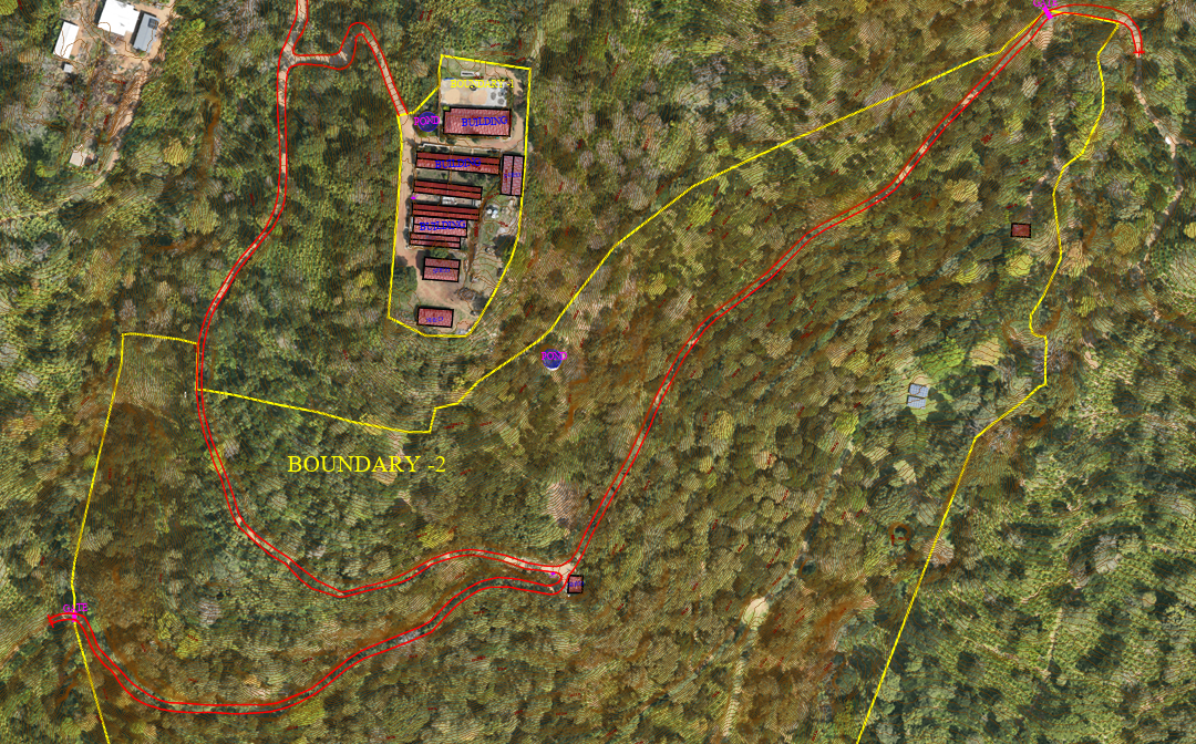
Bare-earth Digital Terrain Model (DTM) — The primary deliverable. A continuous elevation model of the actual ground surface with vegetation removed. This is the foundation for all architectural and engineering design — building placement, foundation design, retaining wall planning, road alignment, and drainage design. Delivered in GeoTIFF and AutoCAD-compatible formats.
Contour map — Contour lines generated from the DTM at 0.5m or 1m intervals (or any custom interval your architect requires). These contours represent the true ground surface, not the vegetation canopy. Delivered in DXF format, ready to import into AutoCAD, SketchUp, or Revit.
Digital Surface Model (DSM) — An elevation model showing all surface features including trees, structures, and terrain. Useful for understanding existing vegetation height, canopy cover, and identifying mature trees that should be preserved in the design.
3D point cloud — The complete raw LiDAR dataset — a dense cloud of millions of georeferenced 3D points classified into ground, vegetation, and structures. Architects can view this in 3D to understand the site’s spatial character before visiting. Delivered in LAS format.
Cross-section profiles — Terrain cross-sections cut at any location and interval you specify. Essential for understanding slope gradients, planning terracing, and designing retaining structures. Delivered in DXF and CSV formats.
Slope and aspect maps — Colour-coded maps showing slope steepness (in degrees or percentage) and slope direction (aspect). Valuable for identifying the most suitable building locations, understanding natural drainage flow, and planning sun-facing orientations for guest rooms.
Orthomosaic map — A high-resolution aerial photograph of the site (captured by RGB camera alongside the LiDAR). At 3 cm ground sample distance, individual trees, pathways, streams, and existing structures are clearly visible. Delivered in GeoTIFF format.
Survey report — A comprehensive PDF documenting methodology, equipment, accuracy achieved, coordinate system, and GCP details.
All deliverables are produced in formats compatible with AutoCAD, Revit, SketchUp, QGIS, ArcGIS, Civil 3D, and other design and planning software used by architects and landscape designers.
Why Architects Prefer LiDAR for Hill Station Projects
We have worked with multiple architecture firms on resort and homestay projects, and the feedback consistently highlights these advantages:
Design confidence. Architects can design with the assurance that their contour data represents the actual ground, not the top of a coffee plantation. Foundation depths, retaining wall heights, and earthwork quantities calculated from LiDAR data are accurate — eliminating the costly surprises that come from designing on unreliable terrain data.
Identify buildable zones. Slope maps derived from LiDAR data clearly show which areas of the plot are suitable for construction (typically below 15–20° slope), which require terracing and retaining walls (20–35°), and which should be left as natural landscape (above 35°). This analysis can be done before a single site visit.
Preserve natural features. The 3D point cloud shows the height and location of every tree on the site. Architects can identify mature trees, stream corridors, rock outcrops, and other natural features to preserve and integrate into their design — a critical consideration for eco-resorts and premium homestays.
Access road planning. The DTM provides accurate gradient data along potential access road alignments. Architects and civil engineers can design roads that stay within safe gradient limits (typically 1:10 to 1:6 for resort access roads), calculate cut-fill volumes, and plan drainage before the road is built.
Regulatory compliance. Many hill station areas have slope-based building restrictions. LiDAR-derived slope maps provide the precise slope data needed for building permission applications and environmental clearance documentation.
How It Works: The Process
Step 1 — Project discussion. You share the site location (Google Maps pin or survey number), approximate area, and what deliverables your architect needs. We provide a quotation within 24 hours.
Step 2 — Planning. Our team checks the DGCA airspace zone for your site, plans the drone flight path to cover the entire property with adequate overlap, and coordinates with you on site access and GCP placement dates.
Step 3 — Field survey (1–2 days). Our DGCA-certified remote pilots arrive at the site with the LiDAR drone and RTK GPS equipment. We set up ground control points (GCPs) surveyed to sub-decimetre accuracy, then fly the LiDAR mission. The entire field operation typically takes 1–2 days for a resort-sized plot (1–20 acres).
Step 4 — Data processing (5–7 days). The raw LiDAR point cloud is cleaned, classified (ground, vegetation, structures), and quality-checked against independent control points. The DTM, contour maps, slope maps, cross-sections, and other deliverables are generated.
Step 5 — Delivery. Complete deliverable package shared via secure download link, with all files in the formats specified by your architect. We walk your architect through the data if needed.
Total timeline: 7–10 days from field survey to final delivery.
How Much Does It Cost?
LiDAR drone surveys for resort and homestay projects typically start at ₹1,00,000 + GST depending on the area, terrain complexity, and location. Factors that affect the cost include the total survey area, distance from Bengaluru (our base), terrain steepness and vegetation density (which affect flight planning complexity), number and type of deliverables required, and the accuracy specifications.
For a typical 2–50 acre homestay plot in Coorg or Chikmagalur, the cost is generally in the range of ₹1,00,000 to ₹1,20,000 + GST including mobilisation, GCP survey, LiDAR flight, processing, and complete deliverable production.
For larger resort projects (50–250 acres) or multi-plot developments, we provide project-specific quotations. Repeat surveys for construction monitoring are available at reduced rates.
This investment is a fraction of the cost of a single retaining wall redesign or foundation correction that can result from inaccurate terrain data. Architects who have worked with both traditional surveys and LiDAR consistently find that the LiDAR data pays for itself in avoided redesign and construction surprises.
LiDAR vs Photogrammetry: Which One for Your Resort Project?
If your plot is on open, cleared land with minimal vegetation — for instance, an existing paddy field or a cleared plateau — an RGB photogrammetry survey will give you accurate terrain data at a lower cost. Photogrammetry also provides a high-resolution aerial photograph of the site, which is useful for design visualisation.
If your plot has any significant vegetation cover — coffee plantation, areca palms, cashew trees, tropical forest, or even dense scrubland — LiDAR is the only reliable option. The cost is higher, but the data is fundamentally more accurate because it captures the actual ground surface, not the vegetation canopy.
Most hill station resort projects have significant vegetation. If you are unsure which method your project needs, share your site location with us and we will advise based on satellite imagery and terrain analysis — there is no charge for this initial assessment.
For a detailed comparison, read our blog post: LiDAR vs Photogrammetry: Which Drone Survey Method Do You Need?
Frequently Asked Questions
Can LiDAR survey be done without cutting any trees? Yes. That is one of the primary advantages. The drone flies above the canopy at 80–100 metres height. No trees need to be cut, no undergrowth needs to be cleared, and no ground access is needed for the majority of the site. Only a few small cleared spots are needed for GCP placement.
How accurate is the terrain data under dense vegetation? With ground control points, our LiDAR surveys achieve ±10–15 cm vertical (Z) accuracy even under dense canopy. This is more than sufficient for architectural design, foundation planning, and retaining wall design.
Can I see the trees and vegetation in the data? Yes. The classified point cloud separates ground points from vegetation points. Your architect can view both — the ground surface for design and the vegetation layer for understanding existing tree cover, height, and density.
Do I need to be present during the survey? Not necessarily. You need to provide site access (gate keys, caretaker coordination, etc.). Our team handles everything else independently. We send you a survey completion report after the field work.
Can the data be used for building permission applications? Yes. The contour maps, slope analysis, and area calculations from LiDAR data are used by architects for building permission submissions and environmental clearance applications across Karnataka, Tamil Nadu, Kerala, and Goa.
What if my plot is in a remote area with no road access? This is common in hill station locations. Our drone equipment is portable and our team can access sites on foot if needed. The drone launches from any small clear area and covers the entire property aerially — ground accessibility does not limit the survey coverage.
Get Started
If you are an architect, developer, or landowner planning a resort, homestay, villa, or hospitality project in a hill station location, share your site details with us for a free assessment and quotation.
- Email: hello@axesmap.com
- WhatsApp: +91 73377 31363
- Website: www.axesmap.com
We operate across all major hill station destinations in South India — Coorg, Ooty, Kodaikanal, Chikmagalur, Sakleshpur, Wayanad, Munnar, Goa, and beyond.
Axesmap (Ejesmapa Technologies Pvt. Ltd.) is a drone survey and mapping company headquartered in Bengaluru with DGCA-certified remote pilots, specialising in LiDAR survey for hilly and vegetated terrain. Visit www.axesmap.com for more information.