LiDAR uses laser pulses to capture 3D terrain data through vegetation. Photogrammetry uses overlapping aerial photographs to create high-resolution 2D maps and 3D models. Both are professional drone survey methods, but they solve different problems. This guide explains when to use each, how they compare on accuracy, cost, and output — and when you might need both.
How Photogrammetry Works
Photogrammetry is the process of extracting 3D measurements from 2D photographs. In a drone survey, a high-resolution camera captures hundreds or thousands of overlapping images as the drone flies a planned grid pattern over your site. Software then matches common points across overlapping images and reconstructs the geometry of the terrain using a process called Structure-from-Motion (SfM).
The result is a dense 3D point cloud from which several products are generated: orthomosaic maps (geometrically corrected aerial imagery), digital surface models (DSM), digital terrain models (DTM), contour maps, and textured 3D mesh models.
At Axesmap, our photogrammetry surveys use a 20MP survey-grade camera that delivers 2.5 cm ground sample distance (GSD) — meaning each pixel in your orthomosaic represents 2.5 cm on the ground. Combined with RTK/PPK GPS and ground control points, this achieves ±5–10 cm horizontal and ±15–20 cm vertical accuracy.
How LiDAR Works
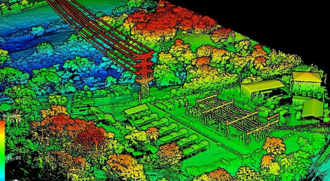
LiDAR stands for Light Detection and Ranging. A LiDAR sensor mounted on a drone emits thousands of laser pulses per second toward the ground. Each pulse bounces back when it hits a surface, and the sensor measures the time it takes to return — calculating the precise distance to that surface.
The critical advantage of LiDAR is multiple return capability. A single laser pulse can partially reflect off a tree canopy, then continue downward and reflect off a branch, and finally reflect off the ground surface below. Each of these reflections is recorded as a separate “return.” This means LiDAR can see through vegetation and capture the true ground elevation underneath — something an RGB camera physically cannot do because it only photographs the visible surface.
The output is a dense 3D point cloud where each point has XYZ coordinates and can be classified into categories: ground, low vegetation, high vegetation, buildings, water, and other surfaces. From the classified ground points, a bare-earth DTM is generated that represents the actual terrain without any vegetation or structures.
Axesmap’s LiDAR surveys produce 200+ points per square metre with multiple return capability, operating at ranges up to 300m above ground level.
LiDAR vs Photogrammetry: Key Differences
Vegetation Penetration
This is the single biggest difference and usually the deciding factor.
Photogrammetry captures what the camera can see — the visible surface. If your site is covered in dense trees, grass, or shrubs, the camera photographs the top of the vegetation, not the ground underneath. The resulting DTM will represent the vegetation surface, not the true terrain.
LiDAR laser pulses pass through gaps in the canopy and reach the ground. Even in dense forest with 80–90% canopy cover, enough laser pulses reach the ground surface to create an accurate bare-earth terrain model. For any site with significant vegetation, LiDAR is the only reliable method for capturing true ground elevation.
Accuracy
Both methods achieve survey-grade accuracy when properly executed with ground control points. Photogrammetry typically achieves ±5–10 cm XY and ±10–20 cm Z accuracy. LiDAR typically achieves ±5–10 cm XY and ±10–15 cm Z accuracy. In open terrain with clear ground visibility, the accuracy difference is negligible.
However, in vegetated or complex terrain, LiDAR is significantly more accurate for ground surface elevation because it directly measures the ground. Photogrammetry in the same conditions would produce a surface model that includes vegetation height, resulting in large errors in the terrain model.
Visual Detail
Photogrammetry has a clear advantage in visual detail. Because it is based on photographs, the output includes full-colour orthomosaic imagery at centimetre resolution. You can zoom into the orthomosaic and visually identify individual objects — vehicles, building features, road markings, drainage structures, vegetation types, and construction materials.
LiDAR produces a point cloud — a collection of XYZ coordinates with intensity values. While this is geometrically precise, it lacks the photographic visual detail. LiDAR does not produce colour imagery unless paired with a separate RGB camera.
Cost
Photogrammetry is the more cost-effective method. RGB cameras are standard equipment, the data volumes are manageable, and the processing workflows are well-established. Typical photogrammetry survey costs range from ₹35,000 to ₹50,000 for a day or for 100acre.
LiDAR surveys cost more — typically ₹80,000 to ₹1,20,000 per day or fr 100 acre — because the sensor equipment is significantly more expensive, the raw data files are much larger (often 10–50x larger than photogrammetry data), and the processing requires specialized software and expertise for point cloud classification and filtering.
Processing Time
Photogrammetry processing is computationally intensive but straightforward. Standard deliverables for a 100-acre site take 3–5 working days.
LiDAR processing involves additional steps — point cloud classification, noise filtering, ground extraction, and quality validation — which can extend the timeline to 5–10 working days for the same area. Complex sites with mixed vegetation, urban structures, and water bodies require more manual classification effort.
When to Use Photogrammetry
Photogrammetry is the right choice when the ground surface is clearly visible and you need high-resolution visual imagery. Common use cases include:
Construction monitoring and progress tracking. Regular drone flights over construction sites produce orthomosaics that visually document progress. Overlaying successive surveys shows exactly what has changed. The visual detail of photogrammetry makes it easy for project managers, architects, and clients to understand the survey output without technical GIS knowledge.
Urban and city-scale mapping. Open urban areas with roads, buildings, and infrastructure are ideal for photogrammetry. Orthomosaics at 2.5 cm GSD provide enough detail for property boundary identification, encroachment detection, road condition assessment, and urban planning.
Land survey for open terrain. Agricultural land, barren plots, quarry sites, and construction land with minimal vegetation are well-suited for photogrammetry. The DTM derived from photogrammetry is accurate when the camera has a clear view of the ground.
Real estate and property documentation. High-resolution aerial imagery is valuable for marketing, due diligence, layout planning, and pre-construction analysis of development sites.
Mining and stockpile volumetrics. Open-pit mines and stockpile areas have minimal vegetation obstruction, making photogrammetry ideal for volume calculations, cut-fill analysis, and monthly progress tracking.
When to Use LiDAR
LiDAR is essential when you need accurate ground elevation data in areas where vegetation blocks the camera’s view of the ground. Common use cases include:
Forested and vegetated terrain. If your site has dense tree cover, scrubland, tall grass, or plantations, LiDAR is the only reliable method for capturing the true ground surface. This applies to forest mapping, plantation surveys, environmental studies, and ecological assessments.
Railway and highway corridor mapping. Linear corridors often pass through mixed terrain with vegetation, cuttings, embankments, and structures. LiDAR captures the complete 3D profile of the corridor including overhead clearances, vegetation encroachment, and drainage features. Axesmap has completed railway corridor LiDAR mapping for Indian Railways, delivering classified point clouds and cross-section profiles.
Flood modelling and hydrology. Accurate flood inundation modelling requires a bare-earth terrain model that represents the actual ground surface, not the vegetation surface. LiDAR-derived DTMs are the standard input for hydrological analysis, catchment delineation, and drainage network mapping.
Transmission line and pipeline corridors. Utility corridor surveys require clearance measurements between conductors and vegetation, ground elevation profiles along the corridor, and identification of encroachments — all of which require LiDAR’s ability to simultaneously capture ground, vegetation, and infrastructure.
Terrain analysis in hilly or mountainous areas. Steep terrain with vegetation cover requires LiDAR for accurate slope analysis, landslide risk assessment, and road alignment planning.
When to Use Both Together
For many projects, the best approach combines both methods. Flying a drone with an RGB camera and a LiDAR sensor on the same mission — or on sequential flights — gives you the complete picture: LiDAR for accurate ground truth and photogrammetry for visual context.
Infrastructure planning in vegetated areas. You need the bare-earth DTM from LiDAR for engineering design, and the orthomosaic from photogrammetry for visual context, site access planning, and stakeholder presentations.
Mining in partially vegetated sites. The active quarry face and stockpile areas can be surveyed with photogrammetry for volume calculations, while the surrounding vegetated terrain requires LiDAR for accurate topographic context.
Large corridor projects. Railway, highway, and pipeline corridor projects benefit from LiDAR for the complete 3D terrain model and photogrammetry for visual documentation of structures, road conditions, and construction progress.
At Axesmap, our team evaluates each project and recommends the optimal approach — photogrammetry or LiDAR— based on your terrain, vegetation cover, accuracy requirements, and project objectives. Our operators hold valid DGCA Remote Pilot Certificates, and our processing team includes specialists in both photogrammetric and LiDAR data workflows.
Quick Reference: LiDAR vs Photogrammetry
Choose photogrammetry if: Your site has clear ground visibility, you need high-resolution visual imagery, your budget is limited, or your primary deliverable is an orthomosaic map.
Choose LiDAR if: Your site has dense vegetation, you need a bare-earth terrain model, you are doing flood/hydrology analysis, or you need corridor mapping through forested areas.
Get Expert Advice on Your Project
Not sure which method is right for your project? Share your site details with our team. We assess terrain, vegetation cover, and project requirements to recommend the most cost-effective approach that meets your accuracy specifications.
Contact Axesmap:
- Email: hello@axesmap.com
- WhatsApp: +91 73377 31363
- Website: www.axesmap.com/contact
Axesmap (Ejesmapa Technologies Pvt. Ltd.) is a drone survey and mapping company headquartered in Bengaluru with DGCA-certified operators, operating across India. Visit www.axesmap.com to learn more.